
Software / Internet Tools →AllMapSoft Offline Map Maker 8.128
Published by: LeeAndro on 6-01-2021, 02:56 |  0
0

File size: 9,3 MB
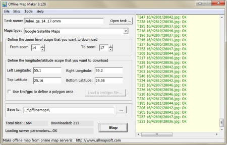
Offline Map Maker is a tool that help you to get offline tile images from Google Maps, Yahoo maps, Bing maps and Openstreetmap.
All ed offline images are saved on your disk. You can view ed offline map by Offline Map Viewer. And you can zoom out or zoom in the offline map, or output the offline map as a .BMP file with a world file xxx.bpw, and can output a xxx.map file for OziExplorer. If you want to make a offline map of your city by yourself, it is very useful for you.
Offline Map Maker is a tool that help you to get offline tile images from many online maps providers, including 300+ maps types: Google Maps, Openstreetmap, Yandex Maps, Yahoo Maps, Mapquest, Gaode map, Tencent Maps, Baidu Maps, Tianditu, 360ditu, Arcgis Online Maps, OneMap for Singapore, Whereis for Australia, mapy.cz, Mappy, Waze Livemap, Hikebikemap, Sentinel-2 map, Strava Gloabal Heatmap, Wikimapia, GoMap.Az, Longdo Map, Bhuvan, National Map Australia, New Zealand Topographic Maps, Map of UAE, ViaMichelin Map, MapFan, Yahoo Japan Map, maps.stamen.com, maps.marshruty.ru, shipxy.com map, Freemap Slovakia, UMP-PC.pl, Vietbando Maps, MinView, Naver, Carte-Géoportail, Wikimedia Maps, OpenSeaMap, CARTO Basemaps, Kort-krak.dk, Mapmyindia Maps, Taiwan Map, GraphHopper Maps, Eniro, Thunderforest, Skoterleder, hitta.se, Maps of Switzerland, maps.lagosstate.gov.ng, NostraMap, Inageoportal, OpenRailwayMap, Public Transport Lines, FINN Kart, waymarkedtrails.org, OpenSnowMap, Navizor, MyGeoMap, META Maps, sogou map, Mapbox, Customized Google Maps, Custom Map Type, etc.
It supports multi-zoom level images , supports kml and gpx as input parameters, can output html files for leaflet, openlayers and googleapi, can output bmp, jpg, tif, png, ecw, sgi, img, kmz as a big map, can output mbtiles for mobile apps to use.
Added 2 new maps type:
The National Map USGSHydroCached (United States) Maps type ID=376
The National Map USGSShadedReliefOnly (United States) Maps type ID=377
Improved Map Combiner, now you can define the extent unit (meters or degrees) of output file by yourself.
DOWNLOAD
uploadgig
rapidgator
nitroflare
Related News
-
{related-news}

